Fishtrap Lake Fishing Spot
- Max Depth: 84'
- Elevation: 1321'
- Last Modified By: vinny60 on 09/09/09 11:46 AM
- Ask about Fishtrap Lake in our Fishing Forums
Photos
Fish Species
Comments
-
Have you fished at Fishtrap Lake? Be the first to comment on this fishing spot.
Fishtrap Lake Description
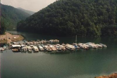
From Pikeville - 12 miles East on U.S. 460 then 2 miles East on State Route 1789. Facilities: 4 recreation areas 32 picnic sites 38 camping sites 7 playgrounds 0 swimming areas 10 trail miles 0 fishing docks 2 boat ramps 1 marinas 86 marina slips Launch ramps for the boating enthusiasts and fishermen are located at the Fishtrap Marina, Grapevine and Lick Creek Recreation Areas. Launching is $3.00 per day at Grapevine and Marina area. Lick Creek offers free launching. Seasonal Passes for launching are available for $30.00 at the Fishtrap Lake Project Office between the hours of 7:30am and 4:00pm. Holders of Golden Age/Access Passports are entitled to 50% discount. Fishtrap Lake is contained by the highest dam in Eastern Kentucky. The U.S. Army Corps of Engineers developed the project after the people of Levisa Fork valley expressed the need for flood control. The U.S. Army Corps of Engineers welcomes you and your family to this vital flood control and recreation development project. Come and enjoy the natural scenic beauty of southeastern Kentucky countryside and the recreational facilities at Fishtrap Lake! The lake is located entirely in Pike County on the Levisa Fork of theBig Sandy River near the states of Virginia and West Virginia. Fishtrap Lake’s primary purpose is reduction of flood damages along Levisa Fork, Big Sandy River and the Ohio River, with minimal reductions on the Mississippi. At its maximum (flood storage) level, the lake would contain more than 54 billion gallons of water. During the summer recreation season, the lake is 16.5 miles long, has a surface area of 1,131 acres and contains about 12 billion gallons of water. It is 84 feet deep at the intake structure during summer pool. Part of this water is released all year for municipal water supply at Pikeville, 15 miles downstream from the dam. After extensive field studies and cost estimates were made, Congress appropriated funds. Construction began in February 1962. President Lyndon B. Johnson dedicated the project on October 26, 1968. The dam, built of native rock with a clay waterproof core, is 195 feet high and 1,000 feet long. The job required moving five million cubic yards of rock and earth. An outstanding job or rock treatment called a 'stairstep' excavation at the left end of the dam exposes the 330,000,000 year old Pennsylvania Period strata. Release of water from the lake is controlled by gates in the tower-like 'intake structure' located at the left end of the dam. From that structure, the water flows through a 15-½ foot diameter tunnel and discharges back into the Levisa Fork below the dam. If the lake should rise above its maximum permissible level during storage of potential floodwaters, then the four 'tainter' gates located in the spillways would be used to control additional releases. It is the policy of the U.S. Army Corps of Engineers to provide a safe, healthy family recreational environment. All recreational areas are closed from 10:00 p.m. until 7:30 a.m. except for persons engaged in boating, fishing and camping. Universally Accessible Facilities are provided at Project Office, Visitor Center, picnic shelters, restrooms, outflow fishing area, camping facilities, and at selective picnic sites. Fishtrap Lake Marina, located at the Dam Site Recreation Area provides visitors with docking facilities and a Concession Area. The Concession Area provides visitors with fuel, live bait, snacks, ice, picnic supplies, etc. . Facilities at this area includes, restrooms, a launch ramp, bank fishing access, basketball court, and picnic sites.
Fishtrap Lake is a 1,130-acre (5 km2) reservoir in Pike County, Kentucky. Dedicated by President Lyndon B. Johnson in 1968, The lake was formed by the impounding of the Levisa Fork of the Big Sandy River at Fishtrap Dam (37°25?55?N 82°24?55?W? / ?37.43194°N 82.41528°W? / 37.43194; -82.41528? (Fishtrap Dam)) by the United States Army Corps of Engineers.[1]