Yatesville Lake Fishing Spot
- Mean Depth: 17'
- Max Depth: 60'
- Last Modified By: vinny60 on 09/15/09 02:44 PM
- Ask about Yatesville Lake in our Fishing Forums
Photos
Fish Species
Comments
-
Have you fished at Yatesville Lake? Be the first to comment on this fishing spot.
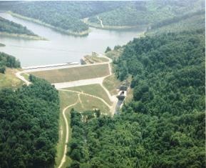
Yatesville Lake Description
Directions: From US Route 23 turn on Route 3 West go 2.5 miles to Route 1185. Take Route 1185 2.5 miles to the Project. Follow signs to the Dam, Project Office/Information Center and the Marina. Yatesville Lake is located entirely in Lawrence County, Kentucky, on Blaine Creek; a tributary of the Big Sandy River. It was built under the Flood Control Act of 1965. The dam is rockfill, with central impervious core and founded on rock. The length of the lake and boatable arms is 20.6 miles upstream from the dam and 18.1 miles upstream from where it flows into the Big Sandy River. The lakes maximum depth is 60 feet with an average mean depth of 17.7 feet. The shoreline measures 93.9 miles at summer pool level. The lake’s watershed is 208 miles. Winter Pool Elevation - 624.0 m.s.l. (1,745 acres) Summer Pool Elevation - 630.0 m.s.l. (2,242 acres) Flood Pool Elevation - 645.0 m.s.l. (3,805 acres) Golden Age and Golden Access passports may be used for a 50% discount at all Federally operated areas where a fee is charged. Yatesville Lake DOES NOT issue these passports, but they can be obtained from any Project that collects user fees. Restrooms are located at the Project Office and at Barkers Launch Ramp Area. Vault Toilets are provided in the downstream area and at Rich Creek Launch Ramp. The restrooms at the project office are only available during normal business hours; 7:30am - 4:00 pm Mon thru Fri. Fishing is allowed from boats and shoreline in and along Yatesville Lake. Monthly trout stockings will start in April and end in October. Launch ramps for the boating enthusiasts and fishermen are located at Barkers, Pleasant Ridge, Rich Creek and Twin Branch. Twin Branch is the only seasonable ramp. All other ramps can be utilized year round. A sixty-site campground is located at Pleasant Ridge (State Route 3215). Of the sixty sites, fifteen will be boat accessible only. With the exception of the boat accessible sites all other sites will have water, electric and sewage hook-ups. Campground is managed by the KY Department of Parks. Universally Accessible Facilities are provided at the Project Office/Information Center, Marina and Barkers Launch Ramp Area. A Universal Access Fishing Jetty is located prior to entering the Barkers Launch Ramp Area. This jetty provides easy access and has proven to be an excellent fishing spot. Yatesville Lake State Park Marina is located at Barkers Launch Ramp area. The Marina is managed by KY Department of Parks and provides customers with docking facilities, boat rentals, boating/fishing and picnic supplies, etc. A picnic shelter is located at the Barkers Launch Ramp Area.