Dix River Fishing Spot
- Elevation: 506'
- Last Modified By: vinny60 on 09/09/09 11:34 AM
- Ask about Dix River in our Fishing Forums
Photos
Fish Species
Comments
-
"Spring bass relate to the shore," Riley says. He points out that when the bass are in their pre-spawn mode, April in most years, they are staging along the channel in areas that are near spawning grounds. Begin your search by locating the channel bends and twists that are near the bank. Then further isolate those areas where the bank provides current breaks and suitable areas for the spawn. Riley suggests looking for rocky areas or outcroppings. If there is sand or gravel in the substrate, that's all the better. Once you find a suitable area, the rock breaks can be depended upon to remain stationary, even during periods of high water or very swift current. According to Riley, buzzbaits have a well-deserved reputation as a hot lure in the early season on the Dix. Anglers would be well advised to carry several with them on their spring outings. The most productive buzzbaits are those that ride high in the water and are easily customized. Riley advises anglers to adjust their baits to generate more or less splash and to vary their retrieval speed until they find the magic combination. Color selection is basic: White, chartreuse and black will cover most situations. Tubes also account for a substantial number of early-season bass. Medium-sized baits in purple, green or pumpkin seem to work best. Many anglers dye the tips of the tentacles chartreuse for increased visibility. Texas rigging is, by far, the most popular. Later in the spring, toward early summer, deep-diving baits will bring arm-wrenching strikes. Lures that dive 6 to 8 feet deep on the retrieve are favored. Again, natural colors seem to work best. Riley further recommends that anglers do not depart the dock without a jig-and-pig tied on at least one rod. He emphasizes that jigs are effective all year, including spring. They can be pitched and flipped into the heavy shoreline cover to effectively work a short strike zone, should the fish be holding tight on cover.
Dix River Description
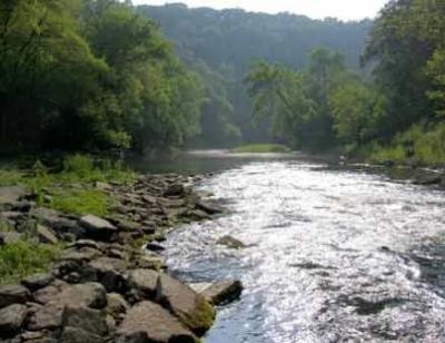
Dix River from Herrinton Lake 2 miles. The Dix River is a tributary of the Kentucky River, approximately 77 mi (124 km) long, in central Kentucky in the United States. It begins in western Rockcastle County, approximately 5 mi (8 km) west of Mount Vernon. It flows generally northwest, in a tight meandering course, passing north of Stanford and east of Danville. Northwest of Danville it is impounded to form the Herrington Lake reservoir. The river then flows approximately 2 mi before joining the Kentucky River near High Bridge, approximately 20 mi (32 km) southwest of Lexington, in the region of the Kentucky River Palisades. The watershed of the river is largely agricultural land, with undulating hills over a bed of limestone. The river is a popular destination for fly fishing, in particular for varieties of bass. Recreational kayakers and canoeists can rarely be found on this river for tame day trips. Water levels are Class I+ with possible mild class II. The lower Dix River Watershed includes the western edge of Garrard County, part of northern Lincoln County, and eastern portions of Boyle and Mercer Counties. The land is characterized by undulating terrain and moderate rates of both surface runoff and groundwater drainage. Most of the watershed lies above thick layers of easily dissolved limestone. Groundwater flows through channels in the limestone, so caves and springs are common in regions with this geology. The lower Dix River watershed includes the river itself from the mouth of Gilberts Creek, southwest of Lancaster, to the confluence with the Kentucky River near High Bridge. Herrington Lake makes up much of this stretch of the Dix River. Among the creeks that feed the river within this watershed are Hawkins Branch, Boone Creek, White Oak Creek, McKecknie Creek, Tanyard Branch, Cane Run, and Rocky Fork. The watershed also receives water from the Dix River (upper), Logan Creek, Hanging Fork Creek, Clarks Run, and Spears Creek & Mocks Branch watersheds. The surface waters of the watershed supply the drinking water for the municipal system in Danville. Eleven businesses and organizations hold permits for discharges into the creeks. The upper Dix River watershed covers southern Garrard County, western Rockcastle County, and eastern Lincoln County. The land is characterized by undulating terrain, moderate to rapid surface runoff, and moderate rates of groundwater drainage. The watershed lies partly above fractured shales through which groundwater can easily move but which stores very little water. The upper watershed of the Dix River includes the headwaters down to the mouth of Gilberts Creek just west of Gilbert (at US 27 between Lancaster and Stanford). Among the creeks that feed it are Negro Creek, Turkey Creek, Copper Creek, Fall Lick, Drakes Creek, Harmons Lick, Walnut Flat Creek, Cedar Creek, Stingy Creek, Turkey Creek, and Gilberts Creek. Located some 30 miles to the south, and just a little west of Lexington near Danville, is one of the best largemouth bass rivers in Kentucky. Often overshadowed by the big waters, it is under appreciated by many anglers, but not by those in the know. The Dix River winds seven miles or so below the dam at Herrington Lake through some of the most spectacular scenery in the country. Bluffs tower over its waters, in some cases rising up 200 feet or more. Heavy forests, interspersed with rocky outcroppings, line the river's banks. If that wasn't enough, the Dix River is full of big bass. Largemouths from 4 to 5 pounds are common, with some bass ranging up to 7 pounds or more. According to Steve Riley, local resident and long-time Dix River angler, there are a number of reasons for the extraordinary population of quality largemouth bass in this venue. First and foremost, in his mind, is the configuration of the river itself. A channel winds to and fro along its length ranging in depth from 12 to over 20 feet. The many sharp turns and bends along the way break the current and provide holding areas for bass. Many of these twists and turns have collected wood debris from the surrounding countryside. This creates a lot of fish-holding structure and cover. Secondly, there is an extraordinary amount of shoreline cover along the Dix River's length. An angler will look long and hard to find a stretch of barren bank along the Dix. Nearly every foot of its banks are covered with laydowns, stumps or wood of some sort. In the few places where wood is scarce, there will likely be an abundance of rock. The type of rock that is sharp and jagged, which provides shelter and current breaks for both forage and bass. Last, but certainly not least, according to Riley, is the river's nearly constant current. This final stretch of the Dix is fed from the dam at Herrington Lake. The current varies in strength, according to the generation schedule at Herrington, but there is always some current. Riley theorizes that this keeps the water fresh and highly oxygenated. While small, the Dix River is big enough to handle almost any size fishing boat. On a recent outing, Riley and Mulberry saw craft ranging from a canoe to a 21-foot bass boat powered by a 200-horse outboard. There are no facilities in the area or on the water. Make sure you have plenty of fuel and everything else you will need. After that, enjoy your trip.
The Dix River is a tributary of the Kentucky River, approximately 77 miles (124 km) long, in central Kentucky in the United States.